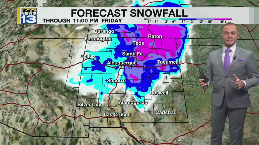
A major winter storm will start moving into New Mexico Wednesday. The storm sticks around through Friday, bringing heavy snowfall and near-blizzard conditions to parts of the state.
Tuesday is the calm before our next storm here in New Mexico. After valley fog developed this morning, the sunny and warmer weather this afternoon, clouds are beginning to move in from the northwest. Overnight and into Wednesday morning, a strong cold front will begin pushing in from the northwest. Along and behind this front will be light rain and snow. Impacts from this rain and snow will be minimal through mid-Wednesday morning, but temperatures will be staying chilly behind the front as it moves east across the state.
Impacts from this winter storm will increase starting Wednesday afternoon as a backdoor cold front moves into northeast New Mexico. This will start a period of heavy snowfall in northeast New Mexico and the Sangre de Cristo Mountains, including the I-25 corridor. As this front moves into Albuquerque Wednesday night, it could bring the Metro a quick burst of snowfall.
Snowfall will pick up in intensity across northern, central, and eastern parts of New Mexico Wednesday night into Thursday morning. Serious to major impacts are expected in the Sangre de Cristo Mountains, northeast New Mexico, and east-central New Mexico, including the East Mountains, beginning Thursday morning. For these areas, I would plan on getting home by Wednesday evening and be prepared to not leave until Saturday. Winds will be picking up in eastern New Mexico Wednesday night, which will cause near-blizzard conditions. I-40 from Tijeras to Santa Rosa and I-25 from Santa Fe to the Colorado state line may become life-threatening to travel on by Thursday morning. The biggest question Thursday is where the rain and snow line sets up. It could set up as far south as Roswell, bringing a wet snow to the Roswell area through Friday.
Snow and some rain will stick around Friday, mainly in central, northern, and eastern New Mexico. Heavy snow will continue to fall in northeast New Mexico. The rain and snow will finally wrap up by late Friday night. Once all is said and done, 10′ to 15′ snow drifts will be possible in parts of northeast New Mexico through Friday, with over 10″ of snowfall. 12-24″+ of snow will be possible in the Sangre de Cristo Mountains. Elsewhere, 4-12″+ of snow will be possible above 7,500′ with 1-6″+ of snow below 7,500′.
Drier weather returns Saturday all across New Mexico. It will be a chilly day, but we will start a warming trend. Temperatures will continue to warm with dry weather through early next week.
Copyright 2024 Nexstar Media, Inc. All rights reserved. This material may not be published, broadcast, rewritten, or redistributed.


Leave a Comment