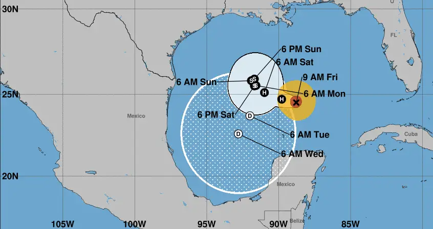
Hurricane Rafael remained a “powerful compact hurricane” as it slowly churned in the central Gulf of Mexico, U.S. forecasters said Friday.
Where is the storm and what is its path?
According to the latest update from the National Hurricane Center, Rafael is located about 230 miles north of Progeso, Mexico and 475 miles east of the mouth of the Rio Grande. It is moving west at 9 mph.
“A slower west-northwestward motion is expected during the next day or so,” the hurricane center said. “After that, Rafael is likely to meander over the central Gulf of Mexico through early next week.”
Rafael is currently a Category 2 storm with maximum sustained winds of 100 mph. But “steady weakening is expected during the next few days,” the hurricane center said.
Rafael made landfall in the Cuban province of Artemisa, just east of Playa Majana, on Wednesday, with maximum sustained winds of 115 mph, weakening slightly as it crossed the island.
What is the expected impact of Rafael?
There are currently no coastal watches or warnings associated with Rafael, but the hurricane center said that “interests in the southern and southwestern Gulf of Mexico” should monitor its progress.
“Swells generated by Rafael are expected to spread across most of the Gulf of Mexico during the next few days,” the hurricane center added. “These swells are likely to cause life-threatening surf and rip current conditions.”
Will it hit the U.S.?
It’s too early to say. Long-range forecasts models are not in agreement on its ultimate path as Rafael encounters wind shear and drier air in the gulf.
“Slight differences in Rafael’s intensity and atmospheric steering winds could have a significant impact on its final track,” AccuWeather meteorologist Bill Deger told USA Today. “It is also possible Rafael is torn apart by strong winds high in the atmosphere and dissipates in the Gulf of Mexico before making landfall.”


Leave a Comment