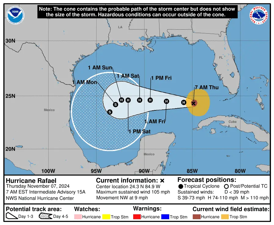
Hurricane Rafael made landfall in western Cuba as a Category 3 storm Wednesday and continued to move toward the northwest Thursday morning, according to the National Hurricane Center.
The National Hurricane Center said at 4:15 p.m. ET Wednesday the storm struck the Cuban province of Artemisa just east of Playa Majana carrying sustained winds of up to 115 mph, bringing down the island’s electrical grid.
As the center of Rafael moved on to the Gulf, parts of western Cuba were experiencing “life-threatening storm surge” and flash flooding, the hurricane center said Wednesday evening. All the while, the island’s entire population of 10 million was once again left in the dark, a crisis repeated several times over the last three weeks.
The hurricane center said a turn toward the west at a slower forward speed is expected Thursday, with this general motion continuing through Saturday. Maximum sustained winds are near 105 mph with higher gusts as of Thursday morning, and some weakening is anticipated during the next few days, the NHC said.
On the forecast track, Rafael is expected to move over the southern Gulf of Mexico for the next few days.
Additional rainfall amounts of 2 to 4 inches are expected Thursday, leading to total accumulations of 12 inches across portions of western Cuba. Swells generated by Rafael are expected to spread across most of the Gulf of Mexico from east to west during the next several days, according to the hurricane center.
“These swells are likely to cause life-threatening surf and rip current conditions,” the NHC said in an advisory Thursday morning.


Will Hurricane Rafael hit the US?
Rafael is expected to follow a northwestern path after leaving Cuba and “meander over the south-central Gulf of Mexico this weekend and early next week,” the hurricane center said, adding that those in the southern and southwestern parts of the Gulf should keep track of its progress.
As the storm churns in the Gulf, it is expected to weaken as it encounters wind shear, drier air, and cooler waters. Long-range forecast models are not in agreement and show the storm could have direct impacts anywhere from eastern Mexico to Texas, Louisiana, Mississippi, and the Florida Panhandle.
“Once in the Gulf of Mexico, slight differences in Rafael’s intensity and atmospheric steering winds could have a significant impact on its final track,” said Bill Deger, a meteorologist with AccuWeather. “It is also possible Rafael is torn apart by strong winds high in the atmosphere and dissipates in the Gulf of Mexico before making landfall.”
AccuWeather says steering winds from a storm over the south-central U.S. are raising uncertainty in the forecast track. The hurricane center cautioned there was also “larger-than-normal uncertainty regarding Rafael’s intensity later in the forecast period.”
Despite its expected weakening in the Gulf, Rafael and its winds will be large and strong enough to create rough seas and life-threatening surf and rip current conditions, according to the hurricane center.
Hurricane Rafael path tracker
This forecast track shows the most likely path of the center of the storm. It does not illustrate the full width of the storm or its impacts, and the center of the storm is likely to travel outside the cone up to 33% of the time.
Hurricane Rafael spaghetti models
Illustrations include an array of forecast tools and models, and not all are created equal. The hurricane center uses only the top four or five highest performing models to help make its forecasts.
Gabe Hauari is a national trending news reporter at USA TODAY. You can follow him on X @GabeHauari or email him at Gdhauari@gannett.com.
This article originally appeared on USA TODAY: Hurricane Rafael tracker: See projected path, spaghetti models


Leave a Comment